I suggest to use the encryption number key if you select to upload data to my web server.
Receiver user can use decryption for find track the other user location.
You can erase webserver data with erase server button from setup menu.
User can choice if want to upload data to my web server.
Work as Internet VHF channel for communication between team users.
I changed the file to upload data for this application to http://www.power7.net/marineloc.php
If you want to see the upload data visit http://power7.net/marineloc.txt
Share your track and position with friends or boats team or family instantly and in
real time via sms or cloud (internet).
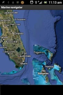
I added aslo a map to shows your position in real time.
You can see your position in real time in the map, or other users of my app
if they uploads data to my web server.
In the next version you will can plot routes.
I will add system for avoid collisions and others functions for safe marine navigation.
I added Alarm Elevation or Sea depth, for example when depth is higher > - 10 m
the alarm fire or when depth is lower < - 200m.
The alarm zone must setup from user.It needs internet connection to work this function!!!
The accuracy does not the same such as a real depth meter.
Added new function: You can create account into my site, register page for use as vessel calendar.
If you use username, enable upload server and run my application you can see your
history location private data into Login page after login.
Also store your last location in SD card.
New function:1. Added Geofense alarm.
When lat>y1 or latx1 or lonFor not alarm fire set up as default values lat +180-180 lon +90-90.
2.Location Name infos.
3.Marine Weather infos.
4.When you touch a point on map you can get the coordinates,distance,bearing from current location.
Stay online and update it because i improve continuously my code!!!
Visit my site http://www.power7.net/marine_navigator.html for more instructions and setup.
For more details send me e-mail.
We do not host Marine navigator - Fish finder on our servers. We did not scan it for viruses, adware, spyware or other type of malware. This app is hosted by Google and passed their terms and conditions to be listed there. We recommend caution when installing it.
The Google Play link for Marine navigator - Fish finder is provided to you by apps112.com without any warranties, representations or guarantees of any kind, so access it at your own risk.
If you have questions regarding this particular app contact the publisher directly. For questions about the functionalities of apps112.com contact us.

|
| ||||
| Downloads: 1395 | ||||
| Updated At: 2024-04-23 08:41:48 | ||||
| Publisher: POWER7 NET | ||||
| Operating System: Android 2.1 And Up | ||||
| License Type: Free Trial |